What grows where?
Spin-off CORAmaps observe agricultural land with satellite radar
2021/04/19
They use radar signals to observe agricultural land around the world, and want to score points on the market with AI-supported technology that is more precise, faster and more reliable than previous solutions. CORAmaps co-founder Markus Huhn on a business model that fits perfectly into the digital economy, and the tightrope walk that is currently being carried out by a TU Darmstadt start-up funded by an EXIST research transfer.

Mr. Huhn, why have you focused your new monitoring technology on agriculture?
Markus Huhn: Because agricultural landscapes change so quickly. Every year we have entirely new vegetation here. Wheat, rye, corn or rapeseed fields also look completely different, depending on the season. And: plants grow at different speeds and different times due to the constantly changing environmental conditions in various places. Mapping this tremendous dynamic in the earth observation is an exciting challenge. And there aren't many people who can do this.
A separate key for every crop
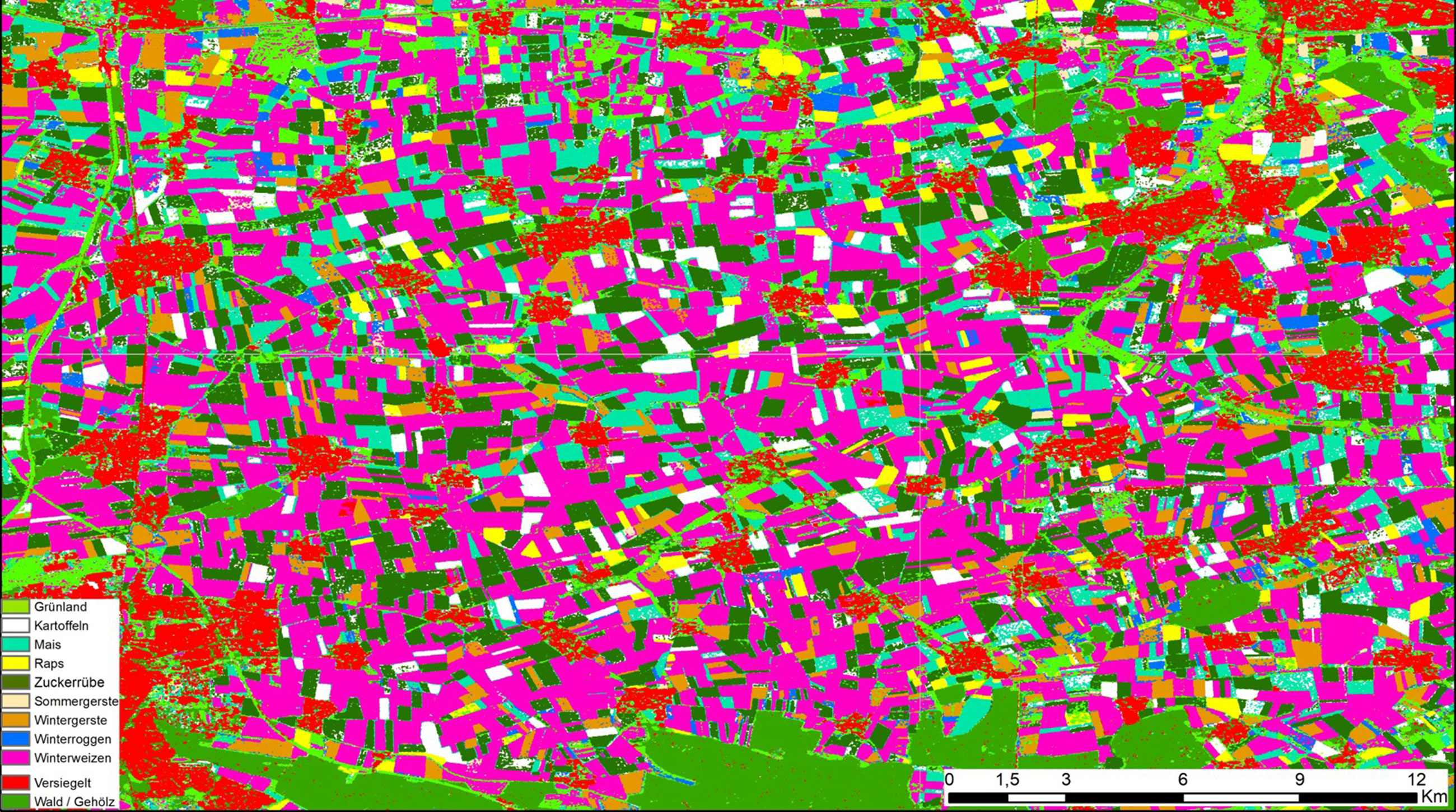
How was agricultural land scanned and analysed before now?
Up to now, large-scale analysis of the agricultural structure was carried out by means of on-site surveys and extrapolations. In addition, all our competitors use optical satellite data. This usually works well when you look at limited areas in a dry summer. However, optical sensors can't see through clouds. Everyone is trying to solve this problem at the moment.
What approach is CORAmaps pursuing?
An entirely new one. Rather than optical sensors, we use radar signals, especially those from the Sentinel-1 satellites of the European Copernicus programme. These signals do pass through cloud cover. This means that once a week, we have a complete picture of the whole earth. Of course, the human eye can't see much on a radar image like this. All it can see is black, grey and white areas.
How do you solve this problem?
This is where AI comes in. We train our monitoring system with data that we collect once at a specific location. We then use this data to teach it at what point in its growth a plant receives which radar signal. In other words, we program a separate key for every crop that the algorithm then recognises. We can then transfer the growth models that are created individually for each plant species to any place on earth. Once developed, our instrument can be used in any region regardless of the prevailing boundary conditions.
“We are currently developing our own market”
What products arise from this data?
First of all, we are currently selling information. What grows where? We make this crop classification available to our customers (now for 14 crops) in the form of Shape files or by means of an interface, which they can then read out and process independently. Next, though, we also want to make further statements with regard to plant vitality, pest infestation or the expected crop yields. We want to use this information perspectively for additional services, for instance for stock letters with growth forecasts.
Who are your customers?
First of all, we are focusing on commodity traders and food producers. Insurance companies are another possibility, as they could use the information for automated policy definition or damage detection. At the moment, we are mainly in touch with major clients who are only just discovering the potential that geoinformatics can have for their business development. Our aim is to offer every customer group individual solutions, so our portfolio will grow with every client. You could say we're currently developing our own market.
“Like riding on a razor blade”
That sounds highly challenging. How did you get so far with your start-up?
The business model was actually clear to us from the beginning, but of course we had to hone it. We went through a long learning process with dedicated mentors and coaches. And it goes without saying that we wouldn't have been able to consider starting this business without the EXIST funding, which we were able to obtain with the support of HIGHEST. This funding secures us our salaries for 21 months and finances a large part of the material costs, so really we've had comparatively little economic pressure so far. Which certainly helps you to sleep better at night.
So what happens next?
We've an awful lot of development work ahead of us, and we need to be quick so that we can meet the individual wishes of the companies and institutions that we are currently working with. At the moment it feels like we're riding on a razor blade. If we have several returning clients in two years' time, we'll be able to live off that very well indeed because we'll be generating the correspondingly high sales. Then we would be able to automatically transfer all the instruments and services that we're developing for our German pilot customers to interested customer groups in every imaginable country and provide them on a platform.
What tip would you like to share with other start-ups?
Networking is the be-all and end-all. You have to start personal talks with people and build trust – in us as founders, and in our ability that we will be able to deliver what we promise. Having trust in us is the most important thing in building up a relationship with the customer.
Interview by Dr. Jutta Witte.
CORAmaps facts and figures
CORAmaps was founded in December 2019 by Damian Bargiel, Pouya Hedayati, Maximilian Guntrum and Markus Huhn as a GmbH, a limited company. The start-up brings together expertise in geodesy, computer science, artificial intelligence and industrial engineering. It is to receive funding of around 800,000 euros by the end of June 2021 as part of the EXIST research transfer, and is a participant in the Copernicus Accelerator. HIGHEST, the innovation and start-up centre of TU Darmstadt, has been accompanying CORAmaps since the autumn of 2017, including with the EXIST application and the acquisition of further funding programmes.